

This presentation discusses a publication about the Nebraska Rainwater Basins. The Nebraska basins are similar to the Carolina Bays, but they have a southwest orientation instead of the southeast orientation of the basins in the East Coast.
The 2025 paper by Hanson and Joeckel is titled: Stratigraphy and OSL chronology of lunette deposits indicates that Nebraska's rainwater basins formed by aeolian deflation between 39 and 25 ka. That is 39 to 25 thousand years ago. The abstract says: The rainwater basins are northeast-southwest oriented deflation basins on an aeolian sediment-mantled remnant alluvial plain south of the Platte River in central Nebraska. Many of them hold runoff, at least seasonally. Most basins are ovoid, with long axes ranging from 1 to 2.5 km in length, and lunettes are commonly found along their southeastern and/or southern margins that stand 8 to 12 m above basin floors. Core stratigraphy indicates that the basins were eroded from Pleistocene alluvium and aeolian sand and later mantled with loess. Lunettes consist of very fine to medium sand capped by Peoria Loess.
The text of the document says that Geomorphologists have generally agreed, since at least the early 1980s, that Nebraska’s rainwater basins are products of aeolian deflation, but divergent theories have also been proposed, including extraterrestrial impact structures potentially related to the Carolina Bays (e.g., Zamora, 2017). The reference to my publication was what brought my attention to this paper. My publication proposes that the Carolina Bays and Nebraska Basins were created by oblique secondary impacts of glacier ice ejected by an extraterrestrial impact on the Laurentide Ice Sheet.
The idea that the Nebraska Basins were geologically related to the Carolina Bays was presented by William Zanner and Mark Kuzila at the GSA annual meeting in November of 2001. This presentation preceded by at least five years the publication of the Younger Dryas Impact Hypothesis, which involved an extraterrestrial impact. The abstract by Zanner and Kuzila says: Our hypothesis is that the basins on the current land surface originally formed as blowouts or low spots in abandoned Platte River fluvial sands and gravels. The term aeolian deflation is now used instead of blowout.
Hansel and Joeckel say that their study is the first to systematically study rainwater basins by providing age control that directly dates basin features, thereby linking their development to widespread climatic and environmental changes during the late Pleistocene. Figure 1 of the paper has a map of the Rainwater Basin Plains showing the basins, major rivers and cities, and the pre-Illinoian glacial limit. The map also identifies the location of the four areas of study: Kearney, Axtell, Fairfield and Fairmont.
Figure 2 shows the western and eastern basins that were studied depicted as hill shade images constructed from LiDAR data using 3X vertical exaggeration. The text says that most of the rainwater basins are ovoid, with long axes aligned prominently northeast-southwest, and are partially bounded by one or more lunettes along their southern, southeastern, or eastern margins.
Figure 3 illustrates topographic cross sections and cores showing general stratigraphy of the loess-covered alluvial plain in the western Kearney basin and the Fairmont site. Cores show Peoria Loess in black over lunette sand in gray.
Table 2 of the publication shows the OSL samples from lunettes at six basins from both the eastern and western parts of the Rainwater Basin Plains. The table has the depth of the sample in meters and the OSL age in thousands of years ago.
I created a scatter plot of the OSL age on the horizontal axis and the sample depth on the vertical axis based on the numbers in this table. From the geological law of superposition, we would expect the OSL age to increase with depth. The plotted points do not show the simple linear trend that I anticipated. This suggests complex depositional histories for the terrain with very scrambled stratigraphy.
Hanson and Joeckel claim that Krueger and Kuzila demonstrated that the basins formed by aeolian deflation and that lunettes formed by the accumulation of deflated sediment immediately downwind. This is an inaccurate statement. There have not been any demonstrations showing that the Nebraska Basins were formed by deflation. There have only been proposals, opinions and hypotheses.
The reference to Krueger is an unpublished master's thesis. Kuzila's work has been published, but it did not demonstrate that the Nebraska basins were formed by aeolian deflation. What Kuzila actually wrote was that it is possible that the pre-Gilman Canyon surface was altered by erosion and deflation, resulting in the formation of basins and accompanying ridges. This possibility is only a hypothesis without proof or experimental evidence. It is very different from the statement that it is possible for hydrogen to combine with oxygen, which is a hypothesis that can be confirmed by experiments. Kuzila also said that the erosion and deflation processes may have been severe enough to expose and deflate sandy material similar to that found below the buried soils in his study. Again, the strength and severity of the hypothetical deflation process is another assumption without material proof. Kuzila says that evidence of the deflation of these sands is suggested by soil surveys from the eastern Rainbasin that show the presence of sandy materials within lunettes.
It is very clear that the aeolian deflation mechanisms for creating the Nebraska basins are only suggestions, proposals, speculations, opinions or purely hypothetical ideas that have not been physically demonstrated by ground observations or by experiments as implied by Hanson and Joeckel. If the wind could make basins, there would be new basins along the path of tornados. Instead, tornadoes leave wide swaths of blown-down trees and wrecked houses broken into splinters, but even these powerful winds don't form new basins. Hurricanes don't create new aeolian basins either.
The aeolian deflation hypothesis for the creation of the Nebraska Basins is an unproven idea. If the winds of tornados and hurricanes are not severe enough to create basins, what kind of winds are needed? Geomorphologists who support the idea that Nebraska’s rainwater basins are the products of aeolian deflation need to come up with better physical explanations.
I will now compare the gray images in the Hanson and Joeckel paper with the colorized LiDAR topography at cintos.org. The basin in Figure 2A has been greatly deformed by a meandering fluvial channel. The size of the basin is difficult to estimate due to the extensive erosion. Figure 2B does not look like a Nebraska Basin at all. The LiDAR image does not show any oval or elliptical features typical of the Nebraska basins. Figure 2C shows a pair of connected basins, both of which have elevated rims or lunettes on their southeast side. The dates obtained from the lunettes vary from 24.3 to 30.4 ka. Figure 2D shows a basin whose western rim has been severely eroded and is connected to a smaller basin on its south. Figure 2E shows several overlapping Nebraska basins. All the basins have well-defined southern rims.
Several years ago, I made a video about these particular Nebraska basins, which are located in the Massie Lagoon Waterfowl Production area about 2.5 miles south of Clay Center, Nebraska. The LiDAR image shows a series of basins that overlap, which according to the impact hypothesis means that these basins were made by a quick succession of adjacent oblique impacts. You can find a link to this video in the description below. Figure 2F does not look like a Nebraska Basin. It has a triangular shape and it does not have the same orientation as other adjacent basins.
It is instructive to compare the OSL dating methodology used by Hanson and Joeckel for the lunettes of the Nebraska Basins with the methodology used by Moore, et al. in the study of Flamingo Bay in South Carolina. Christopher Moore and his coauthors determined the OSL dates at different depths in the same core. This enabled them to correlate the stratigraphy with the temporal chronology of the layers, and it made it possible to identify inverted stratigraphy in the rim of Flamingo Bay.
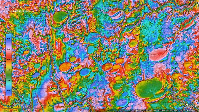
The single OSL dates at each location in the Hanson and Joeckel paper are not sufficient to determine the chronological layering of the terrain. The colorized topography of the LiDAR visualization tool allows us to locate Nebraska basins in very eroded terrain. This particular basin is located about 4 miles south of Friend, Nebraska.
A satellite image of the same area shows only the typical square farm fields of Nebraska with circles made by pivot irrigation systems. LiDAR is an essential technology for the study of the Carolina Bays and the Nebraska Basins. Intensive tilling and water erosion will eventually erase all traces of this basin. The colorized topography has enough contrast to allow us to fit an ellipse to the basin by the least squares method.
The basin has an elliptical geometry that differs by 2.2 percent from a mathematical ellipse. We have to wonder how aeolian deflation can achieve such mathematical perfection, but we also need to question whether the purported aeolian mechanism could have produced this basin. The program that fits the ellipse to the basin also calculates an azimuth of 257.28 degrees. If we draw a great circle trajectory along this azimuth, we encounter Lake Michigan and Saginaw Bay which are convergence points for the orientations of many Carolina Bays and Nebraska Basins.
Let us assume that this Nebraska basin was made by the oblique impact of a piece of glacier ice that was ejected by an extraterrestrial impact on the Laurentide Ice Sheet. From ballistic equations and yield equations that correlate crater size to projectile diameter, we calculate that the ice projectile that made this basin had a diameter of 430 meters and impacted at a speed of about 3 kilometers per second. The energy of the impact was equivalent to about 40.9 megatons of TNT. That is a lot of energy, but it is what it takes to make an elliptical basin measuring 2.1 kilometers in length.
There are many Nebraska basins that have mathematically elliptical geometry and are oriented toward the Great Lakes. The secondary impact model is criticized because it is not supported by stratigraphic analysis and geochronological data, but the aeolian deflation model disregards the constraints imposed by the geometry of the basins and their radial alignment toward the Great Lakes.
Eventually, these divergent models could be combined to describe a landscape of basins formed by secondary impacts of glacier ice that were subsequently altered by water erosion and aeolian mechanisms. The geomorphologists who insist on identifying a purely aeolian deflation mechanism for the formation of the Nebraska Basins should start calculating the energy required to carve each of these enormous basins and then find a credible source of wind that satisfies the energy constraints. It is time to do real physics and stop the hand-waving. The source of wind to form each basin will probably need to be many times more powerful than the category 4 tornado that devastated London, Kentucky on May 16, 2025.
